
Newlyn Walks No. 1
Tolcarne & Bethkele
Tolcarne 1881 click to see a modern aerial view.
THE
Newlyn that we know today was originally divided into separate small
communities, which with the passage of time, and the building of bridges and
roads merged into one. In the 1930's Charles Henderson, the noted Cornish
historian, carried out some research into Cornish place and field names. In
his research he came up with the following names for what has now become
Newlyn:
Lulyn 1289, 1328, 1368;
Lulyn juxta Talcarn 1321;
Bethkele juxta Lewelyn 1388;
Jacford juxta Lulyu 1289;
Lulyn and Jaghford 1424;
Streetonowan (undated).
These then were the separate areas which today make up the whole of Newlyn. In days gone by and even as late of the last century the people living in the different areas tended to stay in their own communities.
This first walk takes us around the area on the Penzance side of the river which is known today as Tolcarne, although it includes the area of Bethkele which seems to have been lost as a place name.
Tolcarne was on the main route to Mousehole for pilgrims on their journey to Santiago de Compostello in Spain. Mousehole was an approved port for the trade in shipping pilgrims. The pilgrims would first visit St Michael's Mount and consequently the road from Marazion and Penzance was well established through the marshes and then along the Eastern Green to Penzance town. Although having a landing place the pilgrims had to travel on to Mousehole because departure from Penzance was not allowed. They may have stopped to pray in the old fisherman’s chapel of St. Anthony on the rocks.
Penzance
was later to become a port with its the docklands, clustered around the piers and customs house, a noisy,
dirty and sometimes dangerous place to be. The trains of packhorses, and their
slimy loads of tin destined for the smelter, often ran free towards their
destination. These were often unaccompanied, as they tended to act somewhat like
homing pigeons apparently. There were also the inns, drinking houses and
gambling dens, frequented by both the ‘paid off ’ sailors and also those of
a somewhat higher station in society. Here were also the slums and
boarding/bawdy houses. Not a place for those with tender sensibilities I
imagine.
After leaving the chapel they crossed the
towans and the morraps. This was all grassy sand dunes and marshland and today
it is commemorated in the name of Morrab Road
and the nearby Morrab gardens.
.jpg)
These rocks would later become the site of the Wherry Mine whose shaft was sited on the rocks out at sea linked to the shore by a jetty. There would also one day be a Tin Smelting works here, but their journey took place 200 years before Godolphin put the Spaniards to flight on this spot in 1595.
The Pilgrims would now have entered the small hamlet known in 1321 as TALCARN, (Tat Cain), brow of the carn. This is the present Tolcarne district, and takes its name from the rock pile that is known as the Devil’s Rock.
But our walk takes us around an area whose oldest buildings date from around the 1750's and detailed records of those who lived here from around the 1840's. In 1760 Tolcarne would have been a very busy place with the boatyards, ropewalk and inn together with the nearby mills and brewery.

The plan is based on the map of MADRON parish in 1841 when a survey was made of all land in England and Wales. This was carried out when they were reforming the tithe system to one of payment in cash rather then the tenth part of all produce, as had been the centuries old custom.
At this date all the land shown in the Tolcarne area was owned by the Le Grice family of Trereife Estate, MADRON
A Mount
Prospect Field [Tolcarne Rock
+ Devils Rock]
B Higher Tolcarne Mill Henry Grylls / John Pollard
C Lower Tolcarne Mill Richard Frean
D Cooperage, Brewery, Offices & Yard Gurney, Downing & others
E Rope Walk Justinian Carter
F
Tolcarne Inn
John Adams
G Smiths Shop Jackeh Rowe
H Smith’s Shop Thomas Cattran
J Timber Yard Abraham Chirgwin
K Miller John Burt
M Farmhouse Charles Ladner
P Orchards William Ladner
Q Carpenter’s Shop William Peake & others
Orchards grew on the Madron side of the river belonging to the Le Grice family and also on the steeper PAUL parish side.
This land was part of the Manor of Lanhydrock, which belonged to the Hon Agar Roberts after he married the heiress to the estate.

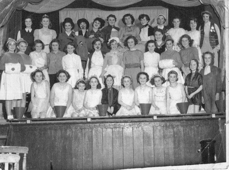
St Peter’s Church was commemorated in 1866. The parish of St Peter was established in 1844 out of parts of MADRON & PAUL parishes. The congregation used to meet in a building on St Peter’s Hill , Newlyn Town for many years. I am not sure if the place was named for the church or visa –versa. The building alongside was originally a schoolroom, afterwards the Parish Hall where an annual pantomime was staged. The photos below are of the cast of two of the productions in the 1950's.

If we were to continue along
the
valley towards
Trereife we would come to the site of
what
was the
Trereife tin smelter at Stable Hobba.
This later became the fish fertilizer plant but after this closed it became a
small industrial estate.
There is now a housing development on the land on the left as you go towards
Stable Hobba, built in the 1960’s by a builder named Cattran.
This was originally market gardens
and there were many lanes
connecting the fields. The main lane was called Paul Hill and is not that of the
same name today.
Trereife
Records show that the Nicholls family owned all of
Newlyn Coombe down to and including Tolcarne foreshore. This included all the
property shown on the section of the 1841 tithe map, towards the Larrigan river
and back up it towards Mount Misery to Trereife House.
William
Nicholls had married Elizabeth Fleming of Landithy, in 1590. Her dowry was
Trereife and the lay tithe of Madron. The estate passed down through the
Nicholls family to William John Godolphin Nicholls who died young in 1815. The
ownership of the estate passed to his mother, a
young widow she had remarried in 1799 to the
BETHKELE, ( Beth Kel), a name dating from 1388 which means hidden grave.
 This
at first seems a little mystifying, but perhaps it has a connection with a
legend that a lancer and his horse were buried in a cave, behind St. Peter’s
Church. This cave is mentioned in Langdon’s Old
Cornish Crosses (1896), page 212, where it is noted that originally- the
cross now on a pillar in the church yard. close to the S.W. of the church, was
dug up on Trereife estate c.1870, and
given by C.D.M. Le Grice Esq., J.P. to the Rev. W. S. Lach-Szyrma. The
vicar fixed it on a rock over a cave situated by the side of the road, not
on the south side of the church, as stated by Langdon, but running along the
N.E. side below the Devil’s Rock. With the development of the land the rock
forming the cave was removed.
This
at first seems a little mystifying, but perhaps it has a connection with a
legend that a lancer and his horse were buried in a cave, behind St. Peter’s
Church. This cave is mentioned in Langdon’s Old
Cornish Crosses (1896), page 212, where it is noted that originally- the
cross now on a pillar in the church yard. close to the S.W. of the church, was
dug up on Trereife estate c.1870, and
given by C.D.M. Le Grice Esq., J.P. to the Rev. W. S. Lach-Szyrma. The
vicar fixed it on a rock over a cave situated by the side of the road, not
on the south side of the church, as stated by Langdon, but running along the
N.E. side below the Devil’s Rock. With the development of the land the rock
forming the cave was removed.
In
1760 Tolcarne would have been a very busy place with the boatyards,
ropewalk and inn together with the nearby mills and brewery. The only
contemporary accounts of Tolcarne at this time speak of Wesley’s first visit.
He is reputed to have preached from the Devils Rock (A on map below). He got a
bit of a rowdy welcome and had to be rescued from the mob by a local man who
thought they were not giving him a fair hearing and should hear him out.


This
was the Manor Mill for Madron. The river is on the left-hand side and also the
building just in the picture is the old Brewery, now the home of a Pilchard
Museum, which does actually produce “fairmaids” and exports them to Italy
There
is the story going around that the owner was struggling to comply with Health
& Hygiene rules and the Health Inspectors wanted to shut it down. “It’s more like a museum than a factory” was their
snide remark. “Well, ef et d’look like a museum, et‘l be a museum” and
he applied for that status, got a grant and now is subsidized by the European
Economic Community [Common Market] to do things in the old way.
He can sell his goods free from the restrictions of modern day
bureaucrats. “Good Luck” to en I say.


G. Site of Jakeh Rowe’s
Blacksmith Shop
Tolcarne
had two smithy's at the time of the Tithe survey in 1841. The
first (G) was in part of what is now a car showroom.
This
three storey yellow building behind the bridge was once the place where the Rowe
family carried on the business of blacksmith for
over a hundred years. It was still there
in the late 1950’s and
a James Rowe was still shoeing horses, mending farm
gates, ploughs and harrows. There was also the huge iron plate set in the ground
where he would form the hoops to fit over the wooden wheels. The smell on cold
days of the burning hooves as he set the shoe, the suck of the bellows and the
strength of the man who was always so quietly spoken are memories safely stored
away. He was the last of them as he only had a daughter, Valerie. The business
of hacking holidays & mobile farriers had not yet materialized and horses
were becoming a rare sight.


H.
Thomas Cattran’s Smithy
As
you walk along Florence Place’ from
Tolcarne place on the right you can see
Thomas Cattrans Smithy
( H ) tucked away in what is now someone's
back garden. The wall facing you is of brick whilst the rest of the building is
stone. Bricks were a rare commodity in Newlyn but some were brought into the
little harbour as ballast in ships coming to load pilchards in the 18th century.
This would mean the smithy was probably
built around that time with bricks made in a foreign
land.

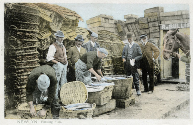
Wallis Basket Makers, hundreds of their baskets were used in transporting fish up country.
The Wallis family worked here
for many years. Fishermen, farmers and miners used baskets. There used to be a
set of granite steps up to the top floor where there is now a balcony. I can
remember the ‘old man’ sitting there in the sunshine, winding his withies
into a flasket that would hold so much washing it was a ‘double hander’.
The building next door, which
is clearer in the picture below, was very long with a wooden upper floor with a
double door opening at some height above the roadway. A block and tackle jerry
rig, hanging from a scaffold pole provided the only access to this loft. Here
the extra long planks, awaiting use in the shipwrights yard opposite, were
stored, sometimes for years, before being used. There was also at one time a
crane beside the water’s edge in the ropewalk area, which was used to get the
boats out over the wall that enclosed the boatyard and into the sea at high
tide. These crane launches were cranked by hand. These boats were clinker built
and used mostly by men who fished for crab or lobster or were longshoremen
lining for mackerel.


Q.
Peake’s
Boat Builders
Turning around from the last
picture and then right at the end of the street is a tiny pathway that goes
between two buildings. The bright white and black one is Peakes Undertakers
–the name remains but the family does not run the business anymore. Across the
lane is a building with stone lower level and wooden upper part, typical of many
old workshops. These are now very scarce as they either get renovated or the
sites built on. This was Peakes boat building yard


Ropewalk
&
Cottage: taken from
position E :
The
cottage on the right was once less than the height of the little white one. It
was probably a workshop converted to a house by adding a stone built upper level
or perhaps a net loft propped up on pillars. The lower level was used to store
things such as salted fish or cutch for barking nets, which would smell too bad
for those who had to live within range. The generous spacing of the doorway and
windows & the different sizes of the upper widows to each other and those on
the ground floor make this a possibility

Matelot’s Cottage:
taken from E


E. Tolcarne Inn looking west
Front Entrance date 1717
The white fronted house on the
right is the start of the new terrace of houses built across the open space by
the J. Burt’s Mill. This was directly opposite the front entrance of the
Tolcarne Inn. A lane had led from here back to Florence Place but whether there
was still access this way after they built the terrace I do not know. If not,
Chirgwin’s timber merchants yard & Thomas Cattran’s smithy and the many
small carpenters workshops would have been blocked off. Perhaps they had already
fallen into neglect before the houses were built. Certainly by 1909 the houses
are there, together with the Florence Place extension up thee steps in picture H
and there is no sign of the buildings that were on the 1841. The little workshop
on picture Q looks like the sole survivor.
The picture of the pub shows that there have been many additions. The bow
windows appeared on the thirties and the surrounding wall sometime after 1970.
The small collection of low buildings at the back may gave been the original
hostelry. The lady of the house taught me music in the 1950’s and I used to
enter through the little back door, now a window. The rooms were low and the
floors below road level and the window opening was very small with tiny panes.
Some even still had ‘bottle bottom’ glass in them. I’m afraid did not pay
much attention to my lessons. Her piano had candleholders, complete with candles
and a lace linen cloth covered the polished lid. On this were placed a
collection of ornaments, the like of which would now fetch a fortune in any
saleroom. My attention was prone to wander.
The only
contemporary accounts of Tolcarne at this time speak of Wesley’s first visit.
He is reputed to have preached from the Devils Rock (A on map below). He got a
bit of a rowdy welcome and had to be rescued from the mob by a local man who
thought they were not giving him a fair hearing and should hear him out.